Datei:SM-3 launch to destroy the NRO-L 21 satellite.jpg

Größe dieser Vorschau: 428 × 599 Pixel. Weitere Auflösungen: 171 × 240 Pixel | 343 × 480 Pixel | 548 × 768 Pixel | 731 × 1.024 Pixel | 1.500 × 2.100 Pixel.
Originaldatei (1.500 × 2.100 Pixel, Dateigröße: 1,74 MB, MIME-Typ: image/jpeg)
Beschreibung
| Beschreibung |
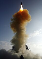
English: The USS Lake Erie (CG 70) launches a Standard Missile-3 at a non-functioning National Reconnaissance Office satellite as it traveled in space at more than 17,000 mph over the Pacific Ocean on Feb. 20, 2008. The objective was to rupture the satellite's fuel tank to dissipate the approximately 1,000 pounds (453 kg) of hydrazine, a hazardous material which could pose a danger to people on Earth, before it entered into Earth's atmosphere. The USS Lake Erie is an Aegis guided missile cruiser. USS Decatur (DDG 73) and USS Russell (DDG 59) were also part of the task force. |
| Datum | Aufgenommen am 21. Februar 2008, 03:26 UTC |
| Quelle | http://www.navy.mil/view_image.asp?id=55403 |
| Urheber | U.S. Navy |

|
Dieses Bild wurde von der US Navy mit der ID 080220-N-XXXXX-032 herausgegeben.
|
Lizenz
Dieses Bild ist das Werk eines Seemanns oder Angestellten der U.S. Navy, das im Verlauf seiner offiziellen Arbeit erstellt wurde. Als ein Werk der Regierung der Vereinigten Staaten ist diese Datei gemeinfrei.
|
 | |
| Es wurde festgestellt, dass diese Datei frei von bekannten Beschränkungen durch das Urheberrecht ist, alle verbundenen und verwandten Rechte eingeschlossen. | ||
Dateiversionen
Klicke auf einen Zeitpunkt, um diese Version zu laden.
| Version vom | Vorschaubild | Maße | Benutzer | Kommentar | |
|---|---|---|---|---|---|
| aktuell | 18:01, 21. Feb. 2008 | | 1.500 × 2.100 (1,74 MB) | wikimediacommons>Uwe W. | {{Information |Description=SM-3 just after launch to destroy the NRO-L 21 satellite |Source=http://www.navy.mil/view_single.asp?id=55403 |Date=February 20, 2008 |Author=unknown |Permission=US Navy photo }} {{PD-USGov-Military-Navy}} |
Dateiverwendung
Die folgende Seite verwendet diese Datei: