Datei:AS16-M-2995.jpg

Datei:AS16-M-2995.jpg

Originaldatei(1.012 × 1.012 Pixel, Dateigröße: 584 KB, MIME-Typ: image/jpeg)

Diese Datei stammt aus Wikimedia Commons und kann von anderen Projekten verwendet werden. Die Beschreibung von deren Dateibeschreibungsseite wird unten angezeigt.

Beschreibung

Beschreibung
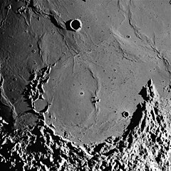
English: The flooded remnant of Letronne crater on the Moon can be seen in this image taken during the Apollo 16 mission. This photo was used in Figure 182 of Apollo Over the Moon: A View from Orbit (NASA SP-362, 1978), which has the following caption:
This arcuate structure is Letronne. It straddles the boundary between southern Oceanus Procellarum and the southern highlands. From "horn to horn" it is about 115 km wide. Astronomers have long recognized Letronne as a crater and geologists also interpret it as a crater because those parts preserved have much in common with better-preserved craters. The preserved crater elements include a large segment of a raised rim, a partly preserved blanket of ejecta occupying depressions along the lower edge of the picture, and the tips of three centrally located peaks that presumably represent the top of a buried central peak complex. The largest and steepest slopes along the rim face inward and probably define the wall of Letronne. The northern one-third of the rim and wall has been almost completely buried by the mare lavas of Oceanus Procellarum. An isolated small hill (arrow) and the crudely arcuate band of mare ridges east of the hill mark the approximate position of the buried rim. The abrupt disappearance of the rim beneath Oceanus Procellarum suggests faulting, but vertical movement without faulting is also possible; this part of Procellarum may have been tilted downward or the adjacent highlands upward.-G.W.C.

Photographic data:

Image Name: AS16-M-2995
Mission: Apollo 16
Revolution (Orbit): 63
Camera: Mapping/Metric
Exposure: 00:00:00.0889
Camera Tilt: VERT
Scan Pixel Scale: 8.198
Start Time: (DOY:115) 1972-04-24T23:30:11
Spacecraft Altitude: 122.43 km
Center Coordinates (lat, lon): -10.15°,-42.71°
Corner Coordinates: -6.85°,-45.72°
-7.2°,-39.33°
-13.61°,-39.61°
-13.21°,-46.2°
Sun Elevation: 4.0°
Features: FLAMSTEED A, LETRONNE, LETRONNE P
Film Type: 3400
Color: black&white
Datum
Quelle

Original: Lunar & Planetary Institute, AS16-M-2995

Update: Arizona State University, Apollo Image Archive, Apollo Browse Gallery, Apollo 16: Mapping (Metric) Camera, AS16-M-2995
Urheber NASA
Diese Mediendatei wurde von einem der Zentren der US-amerikanischen National Aeronautics and Space Administration (NASA) unter der Datei-ID AS16-M-2995 kategorisiert.

Diese Markierung zeigt nicht den Urheberrechtsstatus des zugehörigen Werks an. Es ist in jedem Falle zusätzlich eine normale Lizenzvorlage erforderlich. Siehe Commons:Lizenzen für weitere Informationen.
Sprachen:

Lizenz

Public domain Diese Datei ist gemeinfrei (public domain), da sie von der NASA erstellt worden ist. Die NASA-Urheberrechtsrichtlinie besagt, dass „NASA-Material nicht durch Urheberrecht geschützt ist, wenn es nicht anders angegeben ist“. (NASA-Urheberrechtsrichtlinie-Seite oder JPL Image Use Policy).
Warnung:

Kurzbeschreibungen

Ergänze eine einzeilige Erklärung, was diese Datei darstellt.
Letronne crater on the Moon is seen in this image taken during the Apollo 16 mission

In dieser Datei abgebildete Objekte

Motiv

image/jpeg

77b185e06d380884429b68b8e6eac103672aa5d8

598.087 Byte

1.012 Pixel

1.012 Pixel

Dateiversionen

Klicke auf einen Zeitpunkt, um diese Version zu laden.

Version vomVorschaubildMaßeBenutzerKommentar
aktuell18:19, 21. Sep. 2019Vorschaubild der Version vom 18:19, 21. Sep. 20191.012 × 1.012 (584 KB)wikimediacommons>Jstubyhigher resolution, from ASU

Die folgende Seite verwendet diese Datei:

Metadaten

Die News der letzten Tage