Datei:Mare Orientale - C.jpg
Es ist keine höhere Auflösung vorhanden.
Mare_Orientale_-_C.jpg (350 × 382 Pixel, Dateigröße: 20 KB, MIME-Typ: image/jpeg)
| Beschreibung |
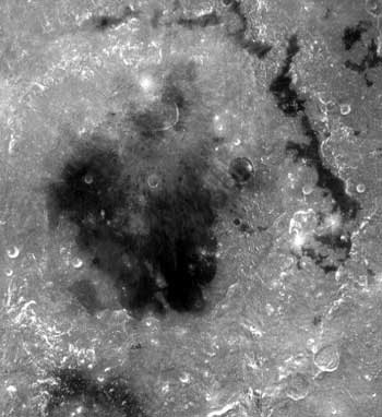
English: en:Mare Orientale straddles both the near and far side. The basin has the most nearly complete concentric ring structure of any basin in the west. The surrounding basin material is of the Lower Imbrian epoch, with the mare material being of the Upper Imbrian epoch. The outermost conspicuous ring is Cordillera, bounded inwardly by steep scarp or gentle lip and topped by some ridgelike massifs. The mare-like material to the northeast is Lacus Autumni. You can also make out the crater Maunder among the northern region of the mare. Off to the southeast of Maunder is Kopff. Montes Rooks lines the eastern edge of the mare. |
| Quelle | http://lunar.arc.nasa.gov/science/atlas/mare/morientale.htm (https://web.archive.org/web/20130221171721/http://lunar.arc.nasa.gov/science/atlas/mare/morientale.htm) |
| Urheber | NASA |
| Diese Datei ist gemeinfrei (public domain), da sie von der NASA erstellt worden ist. Die NASA-Urheberrechtsrichtlinie besagt, dass „NASA-Material nicht durch Urheberrecht geschützt ist, wenn es nicht anders angegeben ist“. (NASA-Urheberrechtsrichtlinie-Seite oder JPL Image Use Policy). | ||
 |
Warnung:
|
Dateiversionen
Klicke auf einen Zeitpunkt, um diese Version zu laden.
| Version vom | Vorschaubild | Maße | Benutzer | Kommentar | |
|---|---|---|---|---|---|
| aktuell | 01:07, 1. Jun. 2007 | | 350 × 382 (20 KB) | wikimediacommons>Bryan Derksen | {{Information |Description={{en|en:Mare Orientale straddles both the near and far side. The basin has the most nearly complete concentric ring structure of any basin in the west.The surrounding basin material is of the Lower Imbrian epoch, with the |
Dateiverwendung
Die folgende Seite verwendet diese Datei: