Datei:A sonda MOR e a acao de seus instrumentos.jpg

Originaldatei (4.000 × 2.944 Pixel, Dateigröße: 832 KB, MIME-Typ: image/jpeg)
Beschreibung
| Beschreibung |
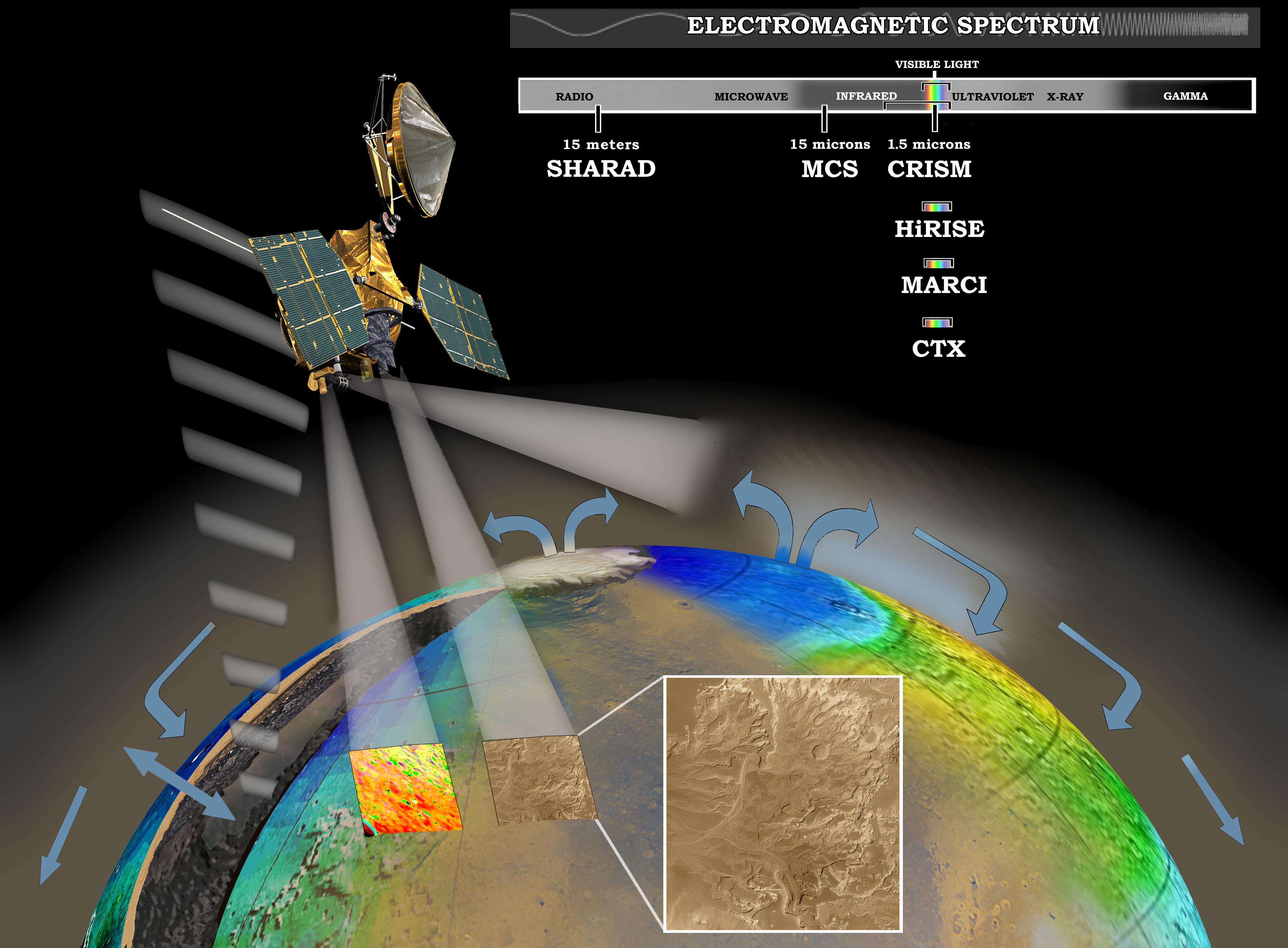
English: MRO investigating Martian water cycle - This artist's concept represents the "Follow the Water" theme of NASA's Mars Reconnaissance Orbiter mission. The orbiter's science instruments monitor the present water cycle in the Mars atmosphere and the associated deposition and sublimation of water ice on the surface, while probing the subsurface to see how deep the water-ice reservoir detected by Mars Odyssey extends. At the same time, Mars Reconnaissance Orbiter will search for surface features and minerals (such as carbonates and sulfates) that record the extended presence of liquid water on the surface earlier in the planet's history. The instruments involved are the Shallow Subsurface Radar, the Compact Reconnaissance Imaging Spectrometer for Mars, the Mars Color Imager, the High Resolution Imaging Science Experiment, the Context Camera and the Mars Climate Sounder.
To the far left, the radar antenna beams down and "sees" into the first few hundred feet (up to 1 kilometer) of Mars' crust. Just to the right of that, the next beam highlights the data received from the imaging spectrometer, which identifies minerals on the surface. The next beam represents the high-resolution camera, which can "zoom in" on local targets, providing the highest-resolution orbital images yet of features such as craters and gullies and rocks. The beam that shines almost horizontally is that of the Mars Climate Sounder. This instrument is critical to analyzing the current climate of Mars since it observes the temperature, humidity, and dust content of the martian atmosphere, and their seasonal and year-to-year variations. Meanwhile, the Mars Color Imager observes ice clouds, dust clouds and hazes, and the ozone distribution, producing daily global maps in multiple colors to monitor daily weather and seasonal changes. The electromagnetic spectrum is represented on the top right and individual instruments are placed where their capability lies.Русский: Шкала работы приборов MRO в электромагнитном спектре частот. |
| Datum | |
| Quelle | http://photojournal.jpl.nasa.gov/catalog/PIA07241 (image link) |
| Urheber | NASA/JPL/Corby Waste |
Diese Mediendatei wurde vom Jet Propulsion Lab der US-amerikanischen National Aeronautics and Space Administration (NASA) unter der Datei-ID PIA07241 kategorisiert. Diese Markierung zeigt nicht den Urheberrechtsstatus des zugehörigen Werks an. Es ist in jedem Falle zusätzlich eine normale Lizenzvorlage erforderlich. Siehe Commons:Lizenzen für weitere Informationen. Sprachen:
|
Lizenz
| Diese Datei ist gemeinfrei (public domain), da sie von der NASA erstellt worden ist. Die NASA-Urheberrechtsrichtlinie besagt, dass „NASA-Material nicht durch Urheberrecht geschützt ist, wenn es nicht anders angegeben ist“. (NASA-Urheberrechtsrichtlinie-Seite oder JPL Image Use Policy). | ||
 |
Warnung:
|
Dateiversionen
Klicke auf einen Zeitpunkt, um diese Version zu laden.
| Version vom | Vorschaubild | Maße | Benutzer | Kommentar | |
|---|---|---|---|---|---|
| aktuell | 20:38, 16. Feb. 2014 | | 4.000 × 2.944 (832 KB) | wikimediacommons>Huntster | Updated version of image. SHARAD operates at 15 meters, not 15 cm. |
Dateiverwendung
Die folgende Seite verwendet diese Datei: